 Consumer drones
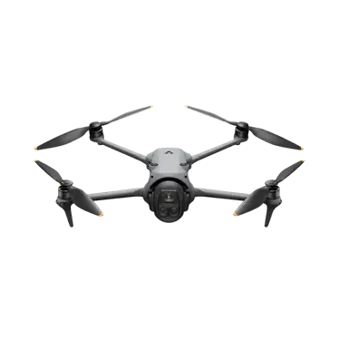
DJI Avata 360
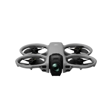
Immersive drone with integrated propeller guards. Dual 1/1.1-inch sensors support 8K/60fps HDR panoramic video in single-lens dual modes, including 360° field of view.
Core Specifications
Product Video Introduction
Video sourced from the official DJI product page for reference.DJI Avata 360appearance and core functionality
* The video is an official DJI product video for reference on product form and features; actual configuration and pricing are subject to inquiry results.
Full Specifications
| Takeoff Weight | Approximately 455 grams |
| Size | Length: 246 mm, Width: 199 mm, Height: 55.5 mm |
| Maximum Ascent Rate | 2 m/s (Eco) 6 m/s (Normal) 10 m/s (Sport) |
| Maximum Descent Speed | 1.5 m/s (Eco) 6 m/s (Normal) 10 m/s (Sport) |
| Maximum horizontal flight speed | 6 m/s (Eco), 16 m/s (Normal), 18 m/s (Sport). Normal mode defaults to a maximum of 12 m/s, adjustable up to 16 m/s in Settings. |
| Maximum Takeoff Altitude | 4500 meters |
| Longest Flight Time | About 23 minutes |
| Longest hover time | About 22 minutes |
| Maximum Range | 13.5 km |
| Maximum wind speed | 10.7 m/s (Wind Level 5) |
| Maximum Tilt Angle | 48° |
| Operating temperature | -10°C to 40°C |
| Satellite Navigation System | GPS + Galileo + BeiDou |
| Hover Precision | Vertical: ±0.1 m (Visual Positioning Normal) / ±0.5 m (Satellite Positioning Normal) Horizontal: ±0.3 m (Visual Positioning Normal) / ±1.5 m (Satellite Positioning Normal) |
| Onboard Memory | 42GB |
| Categories | EU C1 |
| Camera · Image Sensor | Dual 1/1.1-inch square CMOS, single sensor effective pixels: 6400K |
| Camera · Lens | Field of View (FOV): 200° Equivalent Focal Length: 7.8 mm Actual Focal Length: 2.5 mm Aperture: f/1.9 Focus Mode: FF Focus Range: 1.5 m |
| Camera · ISO Range | Panoramic Video: 8K@60/50/48fps: 100 to 12800 (Normal Color/D-Log M) 8K@30/25/24fps: 100 to 25600 (Normal Color), 100 to 12800 (D-Log M) 6K@60/50/48/30/25/24fps: 100 to 25600 (Normal Color), 100 to 12800 (D-Log M) Panoramic Photo: 100 to 6400 Single-Lens Video: 100 to 12800 |
| Camera · Shutter Speed | Recording: 1/8000 s to 1/25 s | Photo: 1/8000 s to 1/30 s |
| Camera · Photo Capture Modes & Settings | Single Shot: In Panorama mode, 3000 million pixels or 1.2 hundred million pixels. 3000 million pixels/8K Panorama photos have a resolution of 7776×3888 (3000 million pixels) in JPEG format and 7680×3840 (2949 million pixels) in DNG format; 1.2 hundred million pixels/16K Panorama photos have a resolution of 15520×7760 (1.2 hundred million pixels) in JPEG format and 15360×7680 (1.18 hundred million pixels) in DNG format. |
| Camera · Maximum Photo Size | Panorama: 15520 × 7760 |
| Camera · Image Format | JPEG/DNG (RAW) |
| Camera · Video Resolution | Panoramic Video: 8K (2:1): 7680 × 3840@60/50/48/30/25/24fps; 6K (2:1): 6000 × 3000@60/50/48/30/25/24fps. Single-Lens Video: 4K (4:3): 3840 × 2880@60/50/48/30/25/24fps; 4K (16:9): 3840 × 2160@60/50/48/30/25/24fps; .7K (4:3): 2688 × 2016@120/100/60/50/48/30/25/24fps; .7K (16:9): 2688 × 1512@120/100/60/50/48/30/25/24fps. Requires Flight Glasses 3/N3 with Goggles Controller 3 or FPV Remote Control 3. |
| Camera · Video Format | OSV/MP4 (H.265) |
| Camera · Max Video Bitrate | 180 Mbps |
| Camera · Color Mode | Normal Mode | D-Log M Mode |
| Camera · Electronic Image Stabilization | Single-lens mode: |
| Camera · Viewpoint | Single-lens mode: |
| Camera · File System Support | exFAT |
| Gimbal · Stabilization System | Single-axis mechanical gimbal (pitch) Panoramic virtual gimbal |
| Gimbal · Structural Design Scope | Pitch: 95° to 173° |
| Pan · Controllable Rotation Range | Single-axis mechanical gimbal: Pitch: -30° to 60° |
| Gimbal · Max Control Speed | Single-axis mechanical gimbal: Pitch: 100°/s. Panoramic virtual gimbal: Pitch: 100°/s, Roll: 100°/s |
| Gimbal · Angle Jitter | Single-axis mechanical gimbal: ±0.01° |
| Perception · Perception System Types | Omnidirectional vision system, paired with a downward-facing infrared sensor and forward-facing LiDAR. |
| Perception · Front | Detection Range: 0.5 to 20 meters | Field of View (FOV): Horizontal 90°, Vertical 90° |
| Perception · Rear View | Range: 0.5 to 18 meters |
| Perception · Side View | Range: 0.5 to 18 meters |
| Perception · Top View | Range: 0.5 to 18 meters |
| Perception · Downward View | 3D ToF Effective Measurement Height: 10 m Precision Hovering Range: 0.3 m to 10 m 3D ToF Field of View (FOV): Horizontal 60°, Vertical 60° Ranging Range: 0.5 m to 20 m Field of View (FOV): Horizontal 90°, Vertical 90° |
| Perceive · Use Environment Effectively | Surface has a diffuse material with rich texture and reflectivity greater than 20% (e.g., concrete pavement). Lighting conditions are sufficient. |
| Video Transmission · Video Transmission Solutions | O4+ |
| Video Transmission · Real-Time Video Quality | Single-camera mode: 1080p@100/60/50/48/30/25/24fps. Panoramic mode: 1080p@60/50/48/30/25/24fps. In single-camera mode, this feature is only available when used with Flight Goggles 3/N3 and the FPV Control Stick 3. |
| Video Transmission · Operating Frequency | 2.400 GHz to 2.4835 GHz 5.170 GHz to 5.250 GHz 5.725 GHz to 5.850 GHz 5.170 GHz to 5.250 GHz. Available only in countries where permitted by local regulations. |
| Video Transmission · EIRP | 2.400 GHz to 2.4835 GHz: < 33 dBm (FCC) < 20 dBm (CE/SRRC/MIC) 5.170 GHz to 5.250 GHz: < 23 dBm (CE) 5.725 GHz to 5.850 GHz: < 33 dBm (FCC) < 30 dBm (SRRC) < 14 dBm (CE) |
| Video Transmission · Communication Bandwidth | Maximum 40 MHz |
| Video Transmission · Maximum Signal Range (No Interference, No Obstructions) | FCC: 20 km | CE: 10 km | SRRC: 10 km | MIC: 10 km |
| Video Transmission · Maximum Signal Range (with interference, no obstruction) | Strong Interference: Urban Center, approx. 1.5 to 4 km Medium Interference: Suburban County, approx. 4 to 10 km Light Interference: Remote Suburbs/Coastal Area, approx. 10 to 20 km |
| Video Transmission · Maximum Effective Range (with interference and obstructions) | Light interference, obstructed by buildings: approximately 0 to 0.7 km. Light interference, obstructed by trees: approximately 0.7 to 4.5 km. |
| Video Transmission · Lowest Latency | Pair with RC 2/RC-N2/RC-N3 aerial remote controller: 1080p/60fps video transmission quality; transmission latency approximately 130 ms. |
| Video Transmission · Maximum Bitrate | 60 Mbps |
| Video Transmission · Max Download Speed | O4+: 10MB/s Wi-Fi 6: 100MB/s |
| Video Transmission · Antenna | 4x4 MIMO (2 transmit, 4 receive) |
| Battery · Capacity | ≥ 2700 mAh |
| Battery · Weight | Approximately 149 grams |
| Battery · Nominal Voltage | 14.32 V |
| Battery · Charge Limit Voltage | 17.2 V |
| Battery · Battery Type | Li-ion |
| Battery · Energy | ≥ 38.67 Wh |
| Battery · Discharge Rate | 7C (typical) |
| Battery · Charging Ambient Temperature | 5°C to 40°C |
| Battery · Charging Time | Using Power Manager (max charging power 100 W): Single battery: from 0% to full charge in approximately 47 minutes; from 10% to 90% in approximately 31 minutes. Three batteries: from 0% to full charge in approximately 100 minutes; from 10% to 90% in approximately 70 minutes. Using Body Charging (max charging power 65 W): Single battery: from 0% to full charge in approximately 73 minutes; from 10% to 90% in approximately 51 minutes. Note: Actual charging times may vary due to ambient temperature or differences in local grid voltage. |
| Chargers · Recommended Chargers | When charging via the Charging Hub with the DJI 65W Portable Charger or DJI 100W Desktop Charger, we recommend |
| Charging Manager · Input | 5 V to 20 V, up to 5 A |
| Charging Manager · Output (Power Collection) | Maximum 60 watts |
| Charge Manager · Output (Charging) | Max 17.2 V |
| Charge Manager · Charging Method | Supports charging up to three batteries simultaneously. If the charger's power is below 65W, the Battery Manager will adjust based on battery levels during charging. |
| Battery Manager · Battery Compatible | DJI Avata 360 Intelligent Flight Battery |
| Storage · Recommended SD Card List | Lexar SILVER PLUS 64GB A2 V30 microSDXC Lexar SILVER PLUS 128GB A2 V30 microSDXC Lexar SILVER PLUS 256GB A2 V30 microSDXC Lexar SILVER PLUS 512GB A2 V30 microSDXC Lexar SILVER PLUS 1TB A2 V30 microSDXC Kingston CANVAS GO! Plus 64GB A2 V30 microSDXC Kingston CANVAS GO! Plus 128GB A2 V30 microSDXC Kingston CANVAS GO! Plus 256GB A2 V30 microSDXC Kingston CANVAS GO! Plus 512GB A2 V30 microSDXC |
| Wi-Fi · Protocol | 802.11a/b/g/n/ac/ax |
| Wi-Fi · Operating Frequency | 2.400 GHz to 2.4835 GHz 5.725 GHz to 5.850 GHz |
| Wi-Fi · Transmit Power (EIRP) | 2.400 GHz to 2.4835 GHz: < 20 dBm (FCC/CE/SRRC/MIC) 5.725 GHz to 5.850 GHz: < 26 dBm (FCC/SRRC), < 14 dBm (CE) |
| Bluetooth · Protocol | Bluetooth 5.4 |
| Bluetooth · Operating Frequency | 2.400 GHz to 2.4835 GHz |
| Bluetooth · Transmit Power (EIRP) | < 10 dBm |
* Specifications are sourced from DJI's official product page; actual configurations may vary by factory. Prices are subject to inquiry.
Download Product Brochure
Below isDJI Avata 360Product Brochure Preview: Click the button to generate and download a PDF version for internal review and selection archiving.
Immersive drone with integrated propeller guards. Dual 1/1.1-inch sensors support 8K/60fps HDR panoramic video in single-lens dual modes, including 360° field of view.
| Takeoff Weight | Approximately 455 grams |
| Size | Length: 246 mm, Width: 199 mm, Height: 55.5 mm |
| Maximum Ascent Rate | 2 m/s (Eco) 6 m/s (Normal) 10 m/s (Sport) |
| Maximum Descent Speed | 1.5 m/s (Eco) 6 m/s (Normal) 10 m/s (Sport) |
| Maximum horizontal flight speed | 6 m/s (Eco), 16 m/s (Normal), 18 m/s (Sport). Normal mode defaults to a maximum of 12 m/s, adjustable up to 16 m/s in Settings. |
| Maximum Takeoff Altitude | 4500 meters |
| Longest Flight Time | About 23 minutes |
| Longest Hover Duration | About 22 minutes |
| Maximum Range | 13.5 km |
| Maximum wind speed | 10.7 m/s (Wind Level 5) |
| Maximum Tilt Angle | 48° |
| Operating Temperature | -10°C to 40°C |
| Satellite Navigation System | GPS + Galileo + BeiDou |
| Hover Precision | Vertical: ±0.1 m (Visual Positioning Normal) / ±0.5 m (Satellite Positioning Normal) Horizontal: ±0.3 m (Visual Positioning Normal) / ±1.5 m (Satellite Positioning Normal) |
| Onboard Memory | 42GB |
| Categories | EU C1 |
| Camera · Image Sensor | Dual 1/1.1-inch square CMOS, single sensor effective pixels: 6400K |
| Camera · Lens | Field of View (FOV): 200° Equivalent Focal Length: 7.8 mm Actual Focal Length: 2.5 mm Aperture: f/1.9 Focus Mode: FF Focus Range: 1.5 m |
| Camera · ISO Range | Panoramic Video: 8K@60/50/48fps: 100 to 12800 (Normal Color / D-Log M) 8K@30/25/24fps: 100 to 25600 (Normal Color), 100 to 12800 (D-Log M) 6K@60/50/48/30/25/24fps: 100 to 25600 (Normal Color), 100 to 12800 (D-Log M) Panoramic Photo: 100 to 6400 Single-Lens Video: 100 to 12800 |
| Camera · Shutter Speed | Recording: 1/8000 s to 1/25 s | Photo: 1/8000 s to 1/30 s |
| Camera · Photo Capture Modes & Settings | Single Shot: In Panorama mode, 3000 million pixels or 1.2 hundred million pixels. 3000 million pixels/8K Panorama photos have a resolution of 7776×3888 (3000 million pixels) in JPEG format and 7680×3840 (2949 million pixels) in DNG format; 1.2 hundred million pixels/16K Panorama photos have a resolution of 15520×7760 (1.2 hundred million pixels) in JPEG format and 15360×7680 (1.18 hundred million pixels) in DNG format. |
| Camera · Maximum Photo Size | Panorama: 15520 × 7760 |
| Camera · Image Format | JPEG/DNG (RAW) |
| Camera · Video Resolution | Panoramic Video: 8K (2:1): 7680 × 3840@60/50/48/30/25/24fps; 6K (2:1): 6000 × 3000@60/50/48/30/25/24fps Single-lens Video: 4K (4:3): 3840 × 2880@60/50/48/30/25/24fps; 4K (16:9): 3840 × 2160@60/50/48/30/25/24fps 2.7K (4:3): 2688 × 2016@120/100/60/50/48/30/25/24fps 2.7K (16:9): 2688 × 1512@120/100/60/50/48/30/25/24fps Requires Goggles 3/N3, along with either the Flight Stick 3 or FPV Remote Controller 3. |
| Camera · Video Format | OSV/MP4 (H.265) |
| Camera · Max Video Bitrate | 180 Mbps |
| Camera · Color Mode | Normal Mode | D-Log M Mode |
| Camera · Electronic Image Stabilization | Single-lens mode: |
| Camera · Viewpoint | Single-lens mode: |
| Camera · File System Support | exFAT |
| Gimbal · Stabilization System | Single-axis mechanical gimbal (pitch) Panoramic virtual gimbal |
| Gimbal · Structural Design Scope | Pitch: 95° to 173° |
| Pan · Controllable Rotation Range | Single-axis mechanical gimbal: Pitch: -30° to 60° |
| Gimbal · Max Control Speed | Single-axis mechanical gimbal: Pitch: 100°/s. Panoramic virtual gimbal: Pitch: 100°/s, Roll: 100°/s |
| Gimbal · Angle Jitter | Single-axis mechanical gimbal: ±0.01° |
| Perception · Perception System Types | Omnidirectional vision system, paired with a downward-facing infrared sensor and forward-facing LiDAR. |
| Perception · Front | Detection Range: 0.5 to 20 meters | Field of View (FOV): Horizontal 90°, Vertical 90° |
| Perception · Rear View | Distance range: 0.5 to 18 meters |
| Perception · Side View | Distance range: 0.5 to 18 meters |
| Perception · Top View | Distance range: 0.5 to 18 meters |
| Perception · Downward View | 3D ToF Effective Measurement Height: 10 m | Precise Hover Range: 0.3 m to 10 m | 3D ToF Field of View (FOV): Horizontal 60°, Vertical 60° | Ranging Range: 0.5 m to 20 m | Field of View (FOV): Horizontal 90°, Vertical 90° |
| Perceive · Use Environment Effectively | Surface has a diffuse material with rich texture and reflectivity greater than 20% (e.g., concrete pavement). Lighting conditions are sufficient. |
| Video Transmission · Video Transmission Solutions | O4+ |
| Video Transmission · Real-Time Video Quality | Single-camera mode: 1080p@100/60/50/48/30/25/24fps. Panoramic mode: 1080p@60/50/48/30/25/24fps. Single-camera mode requires DJI Flight Goggles 3/N3 and a Motion Controller 3. |
| Video Transmission · Operating Frequency | 2.400 GHz to 2.4835 GHz, 5.170 GHz to 5.250 GHz, 5.725 GHz to 5.850 GHz, 5.170 GHz to 5.250 GHz. Available only in countries where permitted by local regulations. |
| Video Transmission · EIRP | 2.400 GHz to 2.4835 GHz: < 33 dBm (FCC) < 20 dBm (CE/SRRC/MIC) 5.170 GHz to 5.250 GHz: < 23 dBm (CE) 5.725 GHz to 5.850 GHz: < 33 dBm (FCC) < 30 dBm (SRRC) < 14 dBm (CE) |
| Video Transmission · Communication Bandwidth | Maximum 40 MHz |
| Video Transmission · Maximum Signal Range (No Interference, No Obstructions) | FCC: 20 km | CE: 10 km | SRRC: 10 km | MIC: 10 km |
| Video Transmission · Maximum Signal Range (with interference, no obstruction) | Strong Interference: Urban center, approximately 1.5 to 4 km Medium Interference: Suburban county, approximately 4 to 10 km Light Interference: Remote suburbs/Coastal area, approximately 10 to 20 km |
| Video Transmission · Maximum Effective Range (with interference and obstructions) | Light interference, obstructed by buildings: approximately 0 to 0.7 km. Light interference, obstructed by trees: approximately 0.7 to 4.5 km. |
| Video Transmission · Lowest Latency | Pair with RC 2/RC-N2/RC-N3 drone controller: 1080p/60fps video transmission quality; transmission latency of approximately 130 ms. |
| Video Transmission · Maximum Bitrate | 60 Mbps |
| Video Transmission · Max Download Speed | O4+: 10MB/s Wi-Fi 6: 100MB/s |
| Video Transmission · Antenna | 4x4 MIMO (2 transmit, 4 receive) |
| Battery · Capacity | ≥ 2700 mAh |
| Battery · Weight | Approximately 149 grams |
| Battery · Nominal Voltage | 14.32 V |
| Battery · Charge Limit Voltage | 17.2 V |
| Battery · Battery Type | Li-ion |
| Battery · Energy | ≥ 38.67 Wh |
| Battery · Discharge Rate | 7C (typical) |
| Battery · Charging Ambient Temperature | 5°C to 40°C |
| Battery · Charging Time | Using Charging Manager (max power 100 W): - Single battery: 0% to 100% in approx. 47 minutes - Single battery: 10% to 90% in approx. 31 minutes - Three batteries: 0% to 100% in approx. 100 minutes - Three batteries: 10% to 90% in approx. 70 minutes Charging via body port (max power 65 W): - Single battery: 0% to 100% in approx. 73 minutes - Single battery: 10% to 90% in approx. 51 minutes *Note: Actual charging times may vary due to ambient temperature or local grid voltage differences.* |
| Chargers · Recommended Chargers | Recommended when charging DJI 65W portable charger and DJI 100W desktop charger via the Charging Hub. |
| Charging Manager · Input | 5 V to 20 V, up to 5 A |
| Charging Manager · Output (Power Collection) | Maximum 60 watts |
| Charging Manager · Output (Charge) | Max 17.2 V |
| Charge Manager · Charging Method | Supports charging up to three batteries simultaneously. If the charger's power is below 65 watts, the Charging Manager will adjust based on battery levels. |
| Charging Manager · Battery Adapter | DJI Avata 360 Intelligent Flight Battery |
| Storage · Recommended SD Card List | Lexar SILVER PLUS 64GB A2 V30 microSDXC Lexar SILVER PLUS 128GB A2 V30 microSDXC Lexar SILVER PLUS 256GB A2 V30 microSDXC Lexar SILVER PLUS 512GB A2 V30 microSDXC Lexar SILVER PLUS 1TB A2 V30 microSDXC Kingston CANVAS GO! Plus 64GB A2 V30 microSDXC Kingston CANVAS GO! Plus 128GB A2 V30 microSDXC Kingston CANVAS GO! Plus 256GB A2 V30 microSDXC Kingston CANVAS GO! Plus 512GB A2 V30 microSDXC |
| Wi-Fi · Protocol | 802.11a/b/g/n/ac/ax |
| Wi-Fi · Operating Frequency | 2.400 GHz to 2.4835 GHz 5.725 GHz to 5.850 GHz |
| Wi-Fi · Transmit Power (EIRP) | 2.400 GHz to 2.4835 GHz: < 20 dBm (FCC/CE/SRRC/MIC) 5.725 GHz to 5.850 GHz: < 26 dBm (FCC/SRRC), < 14 dBm (CE) |
| Bluetooth · Protocol | Bluetooth 5.4 |
| Bluetooth · Operating Frequency | 2.400 GHz to 2.4835 GHz |
| Bluetooth · Transmit Power (EIRP) | < 10 dBm |
Brochures are generated in real-time from page content. If your browser blocks the download, allow pop-ups and try again.
- Professional Scenario Selection Guide
- Customer Service Hotline 4006068166
- Building 7, Compound 2, Guanghua Road, Chaoyang District, Beijing
Purchase Intent
Submit your requirements and contact details. A sales consultant will confirm pricing, stock availability, and delivery options with you. Product prices are subject to quotation.